Drone Intelligence for Construction Sites
Progress monitoring, mapping and inspections for UK construction, delivering clear evidence, faster reporting and repeatable site data
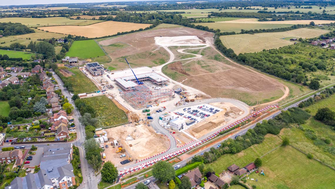
Drone Intelligence for Construction Projects
Aerometrics supports UK construction teams with CAA compliant drone operations designed for live sites. We provide repeatable aerial evidence for progress visibility, coordination and reporting, helping project managers track change, reduce delays and keep stakeholders aligned.
Typical outputs include progress monitoring, surveying and mapping, earthworks volumetrics and as-built verification, delivered in practical formats that slot into existing workflows. High-resolution imagery and video support clearer communication, earlier risk identification and faster decision-making across contractors, consultants and clients.
Where Innovation Meets Site Reality
Our work combines advanced aerial capability with the discipline required on live construction sites. Scheduled progress flights and targeted capture give site teams clear visibility over logistics, material stockpiles and programme milestones.
From earthworks volumetrics and compliance checks to ongoing progress tracking, we deliver consistent, reliable data that integrates smoothly with existing site management and reporting systems.
- CAA certified and fully insured for commercial construction operations
- CSCS and site-aware pilots operating under tailored RAMS
- Secure data handling with outputs suited to construction workflows

Built for Delivery, Backed by Experience
With experience across complex construction programmes, we understand the pressures of time, quality and safety. From early site surveys through to milestone reporting, our aerial data supports informed decisions at every stage of a build.
We work as a dependable extension of your project team, delivering high-precision visual and spatial intelligence quickly and consistently so issues can be identified early and acted on with confidence.
- Experience across logistics, infrastructure and commercial construction
- High-resolution imagery, 3D models and volumetric outputs
- Predictable turnaround times aligned to programme needs
Construction Drone Intelligence
Progress monitoring, earthworks volumetrics and as-built verification to support reporting, coordination and confident decisions.
Typical Construction Projects We Support
Clear, repeatable site intelligence across a wide range of build types and delivery models
Logistics and Warehousing
Progress monitoring and earthworks visibility for large footprints, phased handovers and fast-moving programmes.

Residential Developments
Repeatable aerial updates that support coordination, reporting and stakeholder alignment across multiple plots.
Commercial Construction
Surveying and mapping outputs that support planning evidence, coordination and as-built verification.

Infrastructure and Civils
Practical aerial evidence for enabling works, structures, progress reporting and quality checks.

Frequently Asked Questions
- How often can aerial progress updates be captured?
- Flights can be scheduled weekly, fortnightly or monthly, aligned to programme milestones, reporting cycles and site activity.
- Can drone data integrate with existing construction workflows?
- Yes. Outputs are supplied in practical formats that integrate with common construction, planning and site management platforms, ensuring data is usable without friction.
- Do you provide volumetric and cut-and-fill surveys?
- We deliver accurate volumetric and cut-and-fill analysis to track earthworks progress, material movement and site balance over time.
- Are flights compliant with construction site safety requirements?
- All operations are carried out by CSCS-aware pilots using site-specific RAMS, with clear coordination to minimise disruption and maintain safe working environments.
Ready to apply drone intelligence to your construction project?
Get In Touch
Whether you're interested in our drone services or have questions about how we can help with your specific project, our team is ready to assist you.
Call Us
Monday–Friday, 9am–5pm
Visit Us
By appointment only