Drone Deer Counting and Thermal Wildlife Surveys
Low-disturbance deer population counts across the UK using thermal imaging, mapped outputs and repeatable survey flights that support land management and conservation reporting.
Drone Deer Counting for Land Management and Conservation
Minimal Disturbance. Maximum Clarity.
Aerometrics delivers drone deer counting and thermal wildlife surveys that give land managers, estates and conservation teams defensible population data with far less disruption than traditional ground methods. Our focus is deer counts first, with habitat monitoring and ecology-supporting capture available as supporting outputs where it is useful.
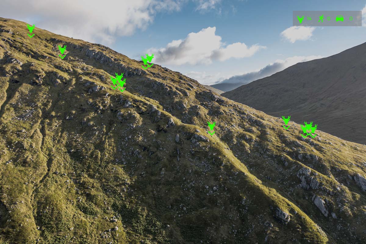
Thermal drone surveys provide a clearer picture of deer numbers, distribution and movement during dawn and dusk windows when detection rates are typically strongest. Flights are planned to reduce disturbance while improving consistency across repeat visits, so you can compare season to season and back up management decisions with mapped evidence.
Thermal Drone Deer Counts and Population Assessment
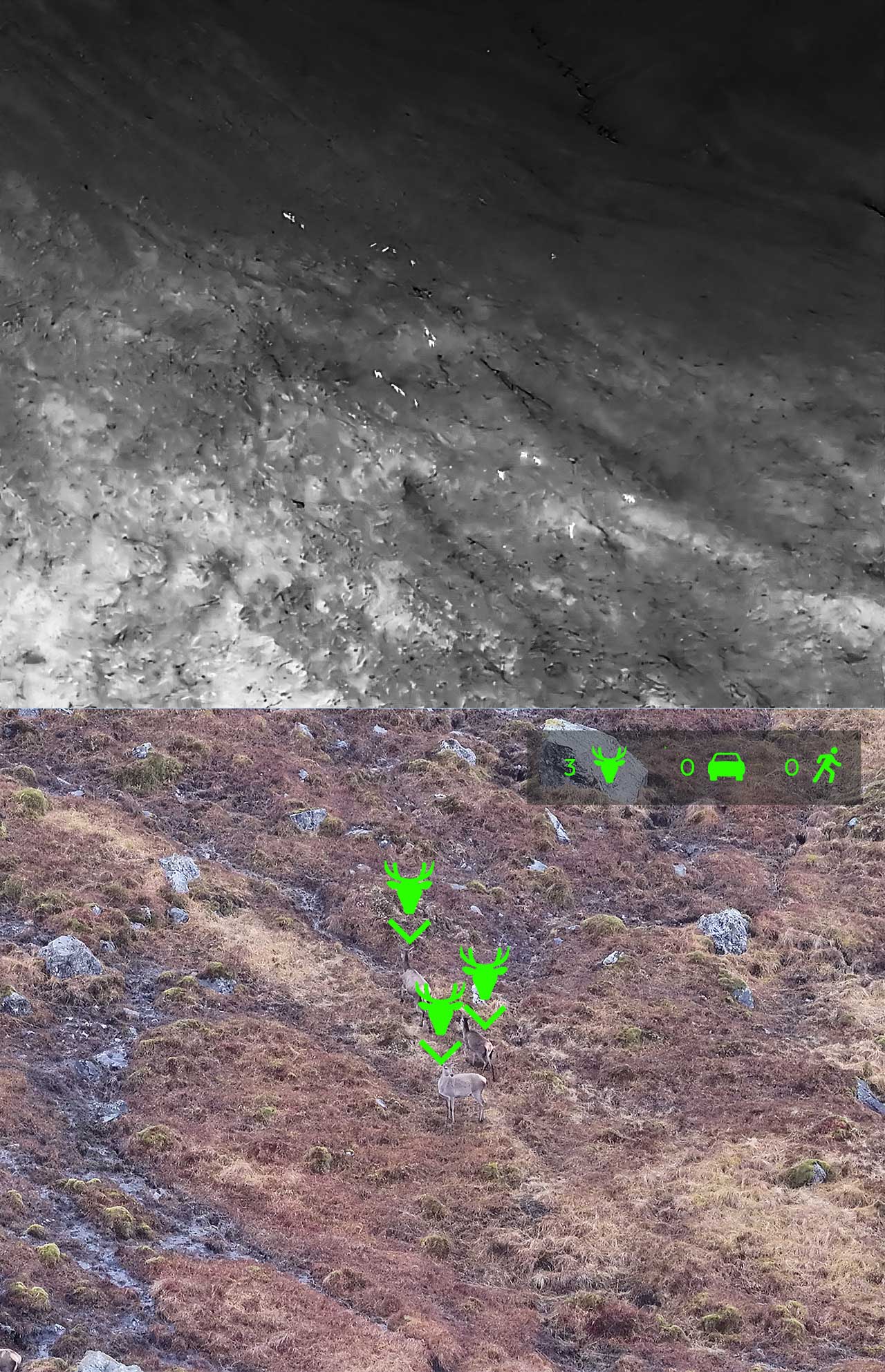
Reliable deer population surveys help prevent overgrazing, protect sensitive habitats and support herd health planning. Aerometrics uses thermal imaging alongside visible-spectrum capture to detect deer more consistently, including when animals are partially obscured by vegetation or moving through woodland edges.
Deliverables are designed for decision-making, not just screenshots. Expect mapped count outputs, location context, and a clear summary that can be used for estate planning, ecological reporting, or stakeholder updates. Repeatable flight routes make it possible to track change over time rather than relying on one-off estimates.
- Deer count estimates with mapped location context
- Distribution and hotspot mapping for management planning
- Repeat surveys for trend comparison across seasons
- Outputs suitable for reporting and evidence packs
Wildlife and Habitat Monitoring
Supporting surveys for habitat condition, vegetation change and ecology-led monitoring with minimal disturbance.
Habitat Monitoring and Low-Disturbance Survey Method
When habitat condition matters as much as the headcount, we capture supporting data to show change in vegetation cover, habitat fragmentation and pressure points such as erosion lines or encroachment. This is useful for conservation planning, baseline records, and tracking whether interventions are actually working.
Survey routes, heights and timings are planned to minimise disturbance and align with the objectives agreed with ecologists or land managers. Deliverables can be supplied in GIS-friendly formats so the data slots into existing records and mapping workflows.
- Vegetation change and habitat condition capture
- Repeatable monitoring for before and after comparisons
- GIS-compatible outputs for mapping and reporting
- Practical flight planning to reduce disturbance
Deer Survey Case Study
A real-world example of large-scale drone deer counting in the Scottish Highlands, combining thermal detection, long-range verification, and fully off-grid field operations.
Glen Dessary Deer Survey
A large-scale aerial deer survey across Glen Dessary, Glen Pean and Glen Ahurran in the Scottish Highlands. Using thermal detection and long-range zoom verification, we delivered a reliable population count in challenging terrain and weather conditions.
| Coverage | 15,000 acres across 3 glens |
| Count | Estate target met |
| Method | Thermal detection + 120x zoom verification |
| Range | 300 to 500m identification |
- Sexed deer and identified calves and young stags
- Operated fully off-grid using Starlink connectivity
- Coordinated with RAF low flying activity
- Continued flying in rain with weatherproof drone
Why Choose Aerometrics for Drone Deer Counting
Purpose-built thermal drone surveys delivering defensible deer population data for land management and conservation decisions.
Deer Counts, Not Generic Wildlife
Surveys are designed specifically for deer population assessment, producing reliable counts and mapped distribution rather than vague wildlife presence data.
Low-Disturbance Flight Method
Altitude, routing and timing are planned to minimise behavioural impact while maintaining consistent thermal detection across woodland and open ground.
Decision-Grade Deliverables
Clear count summaries, mapped context and supporting visuals that can be used directly in management plans, reports and evidence packs.
Repeatable Survey Routes
Fixed routes and consistent methodology allow meaningful comparison across seasons, supporting trend analysis rather than one-off estimates.
Designed to Work With Ecologists
Outputs complement existing ecological oversight and integrate cleanly into wider conservation and land management frameworks.
Fast, Usable Reporting
Turnaround is focused on usability, with counts and maps delivered while the data is still relevant for decision-making.
Drone Deer Counting FAQs
- What weather is needed for a drone deer count?
- Deer counts work best in cool, overcast conditions with no direct sun. Strong sunshine heats the ground and surrounding vegetation, which reduces thermal contrast and makes detection less reliable. Ideally, surveys begin at first light when conditions are at their most stable for thermal work.
- Can you carry out a deer count on a sunny day?
- No, not if you want reliable thermal count data. Bright sun materially reduces the quality of detection, so sunny conditions are not suitable for a proper deer survey. If the thermal conditions are wrong, the survey should be rescheduled rather than forcing poor quality data.
- Can you survey at night?
- No. We do not carry out deer counts at night. The preferred window is first light, when thermal contrast is strongest and conditions are better suited to structured detection, identification and counting.
- Can you fly in the rain or wind?
- Yes, rain is not necessarily a problem and we can operate in wet conditions with the right platform. Wind is the bigger limitation. As a rule, winds above 28mph are beyond the operating limit for this type of survey and would require postponement.
- How much land can be covered in a day?
- That depends entirely on the terrain, access, boundaries and how easily the team can move around the estate. A flat, accessible site is very different from steep or broken Highland ground. We need to review a land plan before confirming likely coverage, timing and price. On larger estates, two or more teams may be needed to complete the work in a single day.
- What help is needed from the client?
- We need support from someone who knows the land well, typically a stalker, keeper or estate representative. They help with boundaries, key areas, access points, terrain considerations and any local knowledge that improves the efficiency and reliability of the count.
- What about access and getting around the estate?
- We operate with a 4x4, but some estates require more robust transport to move safely and efficiently across the ground. If access conditions are beyond what a 4x4 can reasonably manage, the client will need to provide suitable estate transport.
- Can you identify species and sex from the drone?
- Yes. We can identify species, sex and whether animals are older or younger from roughly 500 metres away, depending on conditions, terrain and line of sight. The system is designed not just to detect animals thermally, but to verify them visually as part of the survey workflow.
- Does the time of year matter?
- That depends on what you need from the survey. If the objective is simply a population count, the timing is more flexible and driven mainly by conditions. If you need reliable sexing, it should be carried out at a time when stags still have their antlers, as that makes classification more dependable.
- What do you need before quoting for a deer survey?
- We need a land plan and a basic understanding of the terrain, access, boundaries and survey objective. That allows us to assess likely coverage, decide whether one or multiple teams are needed, and provide a realistic price and programme rather than a guess.
Reliable deer counts without ground disturbance
Get In Touch
If you need accurate deer population data for estate management, conservation planning or reporting, get in touch with details of the land area and survey objectives. We will advise on timing, approach and expected outputs before providing a clear quote.
Call Us
Monday–Friday, 9am–5pm
Visit Us
By appointment only