Case Study: 15,000 Acre Deer Survey at Glen Dessary
A large-scale aerial deer count across three remote Highland glens, combining thermal detection, long-range optical verification, and fully mobile off-grid operations to produce a reliable, decision-ready population dataset.
The Brief: Count Deer Across Three Remote Glens
Aerometrics was tasked with carrying out a deer survey across approximately 15,000 acres of Highland estate land covering Glen Dessary, Glen Pean and Glen Ahurran. This is a substantial and physically demanding area to assess using traditional ground methods alone, particularly where terrain, distance, weather, and access all work against efficient coverage.
The objective was not simply to locate deer, but to build a dependable population count that could support estate management decisions. That meant more than spotting animals at range. It required the ability to identify groups clearly, distinguish between stags, hinds, calves, and younger males, and do so consistently across a wide operating area without causing unnecessary disturbance.
Ground teams working entirely on foot would have faced long traverses, repeated climbs, and limited visibility into neighbouring corries and glens. That would have slowed the operation considerably and increased the chance of partial coverage, duplicate observations, or missed groups moving through broken terrain.
The job therefore called for a survey method that could move quickly, see over the landscape, verify animals with confidence, and keep the field team working in a safer and more efficient way.
A Mobile Survey Platform Built for Estate Work
To make that possible, the operation was built around mobility. An ArgoCat was used to move personnel and equipment around the estate, allowing the team to cover the three glens efficiently while carrying batteries, charging equipment, communications kit, and drone infrastructure with them. This removed the need to keep returning to a fixed base and meant the survey could progress with the ground conditions rather than against them.
That mobility made a real difference. Instead of pushing people into unnecessary climbs simply to maintain line of sight or relocate between areas, the team could remain lower down and reposition more intelligently. In practical terms, that reduced fatigue, reduced exposure to risk, and kept the survey moving at a steady pace throughout the day.
Thermal Detection First, Then Long-Range Verification
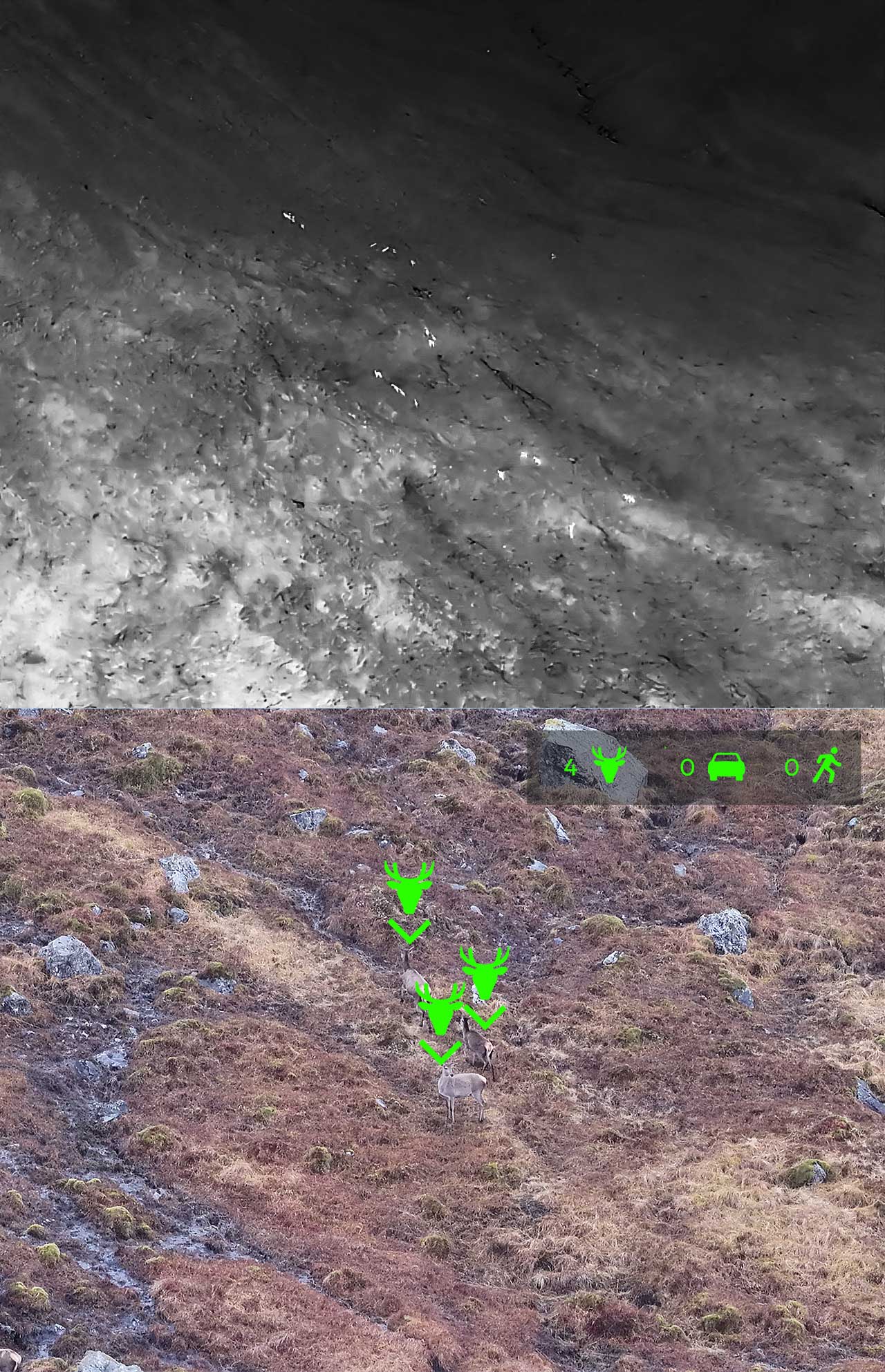
The core survey workflow combined two complementary stages. Initial deer detection was carried out using thermal imaging, allowing the team to scan large areas of ground rapidly and identify heat signatures that would be difficult or time-consuming to pick out with the naked eye alone. This was particularly valuable in broken Highland terrain where deer may be partly screened by contours, heather, rock, or distance.
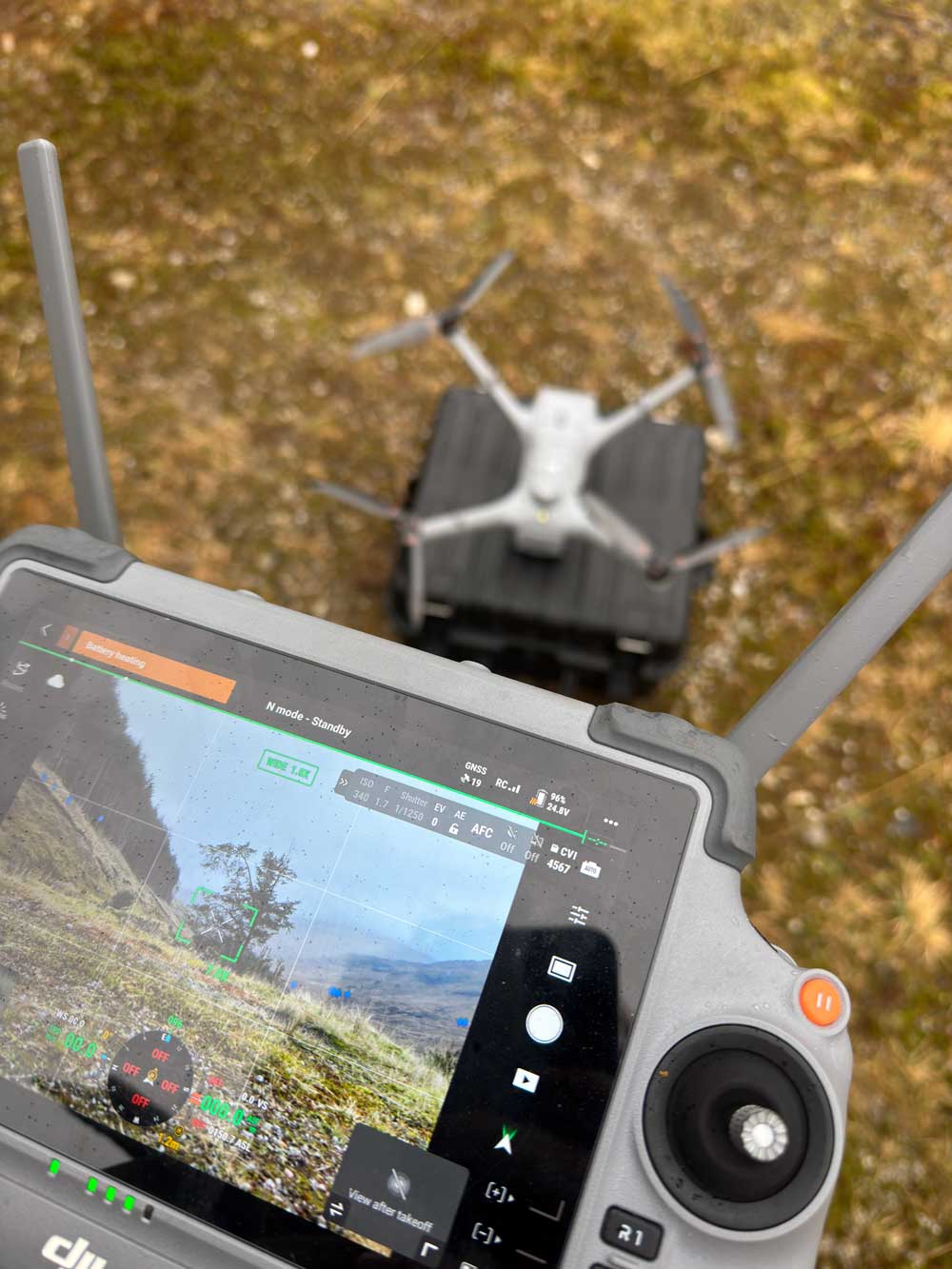
Once animals were identified thermally, they were then verified visually using the DJI Matrice 4TD and its powerful zoom capability. The aircraft allowed the team to assess deer from roughly 300 to 500 metres away, close enough for confident classification but far enough to avoid pushing unnecessarily into the animals and altering their behaviour.
That visual verification stage was critical. It meant the count was not based on heat signatures alone. Deer could be sexed, calves could be distinguished, and younger stags could be noted, producing a more useful and defensible result for the estate than a simple total headcount.
Across the operation, more than 740 deer were identified. The same workflow also picked up other species on the estate, including wild boar and foxes, adding wider wildlife intelligence beyond the primary survey brief.
A Reliable Method for Large-Scale Highland Counting
The strength of this approach was that it combined speed with confidence. Thermal scanning made it possible to cover broad areas efficiently, while the zoom lens provided the detail needed to verify what had actually been found. That pairing is what made the count useful. Without verification, thermal can tell you something is there. With verification, it becomes survey-grade information that can be acted upon.
In estate terms, that means a clearer understanding of population distribution, more reliable numbers for planning purposes, and a better evidence base for future management decisions.
Structured Data Capture in the Field
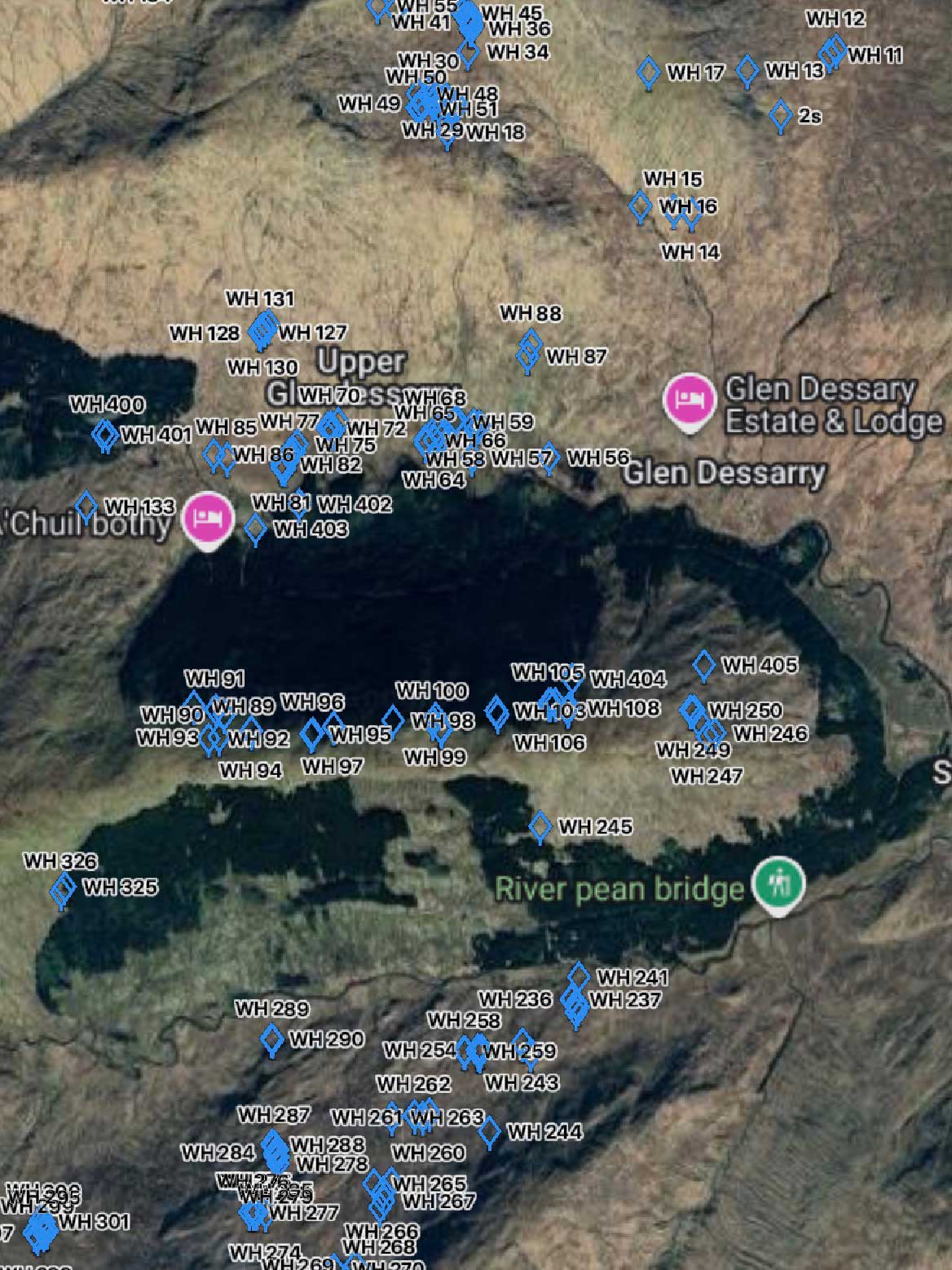
To maintain accuracy across such a large area, sightings were not simply observed and remembered. Intelligent markers were used during the operation to log deer positions directly on the map, helping the team build a live picture of what had already been counted and where. This was an important safeguard against duplication, especially when working across adjoining ground where groups may move between observations.
By marking deer in real time, the survey became more than a sequence of flights. It became a structured mapping exercise with a clear record of detections, classifications, and location context. That is what turns a drone sortie into a usable dataset.
Connectivity was another challenge that had to be solved properly. Much of the estate has little to no conventional mobile signal, so a Starlink Mini was used to maintain data access and keep connectivity to DJI FlightHub available throughout the operation. In a remote Highland environment, that kind of live link is not a luxury. It helps keep planning, oversight, and data handling streamlined when the ground conditions are otherwise working against you.
Power resilience was equally important. A dedicated charging station built into the Argo kept batteries rotating throughout the day, allowing the drone system to remain operational with effectively zero downtime between flights. That matters on jobs like this, because every unnecessary pause costs coverage, daylight, and momentum.
Weather, Airspace, and Keeping the Survey Moving
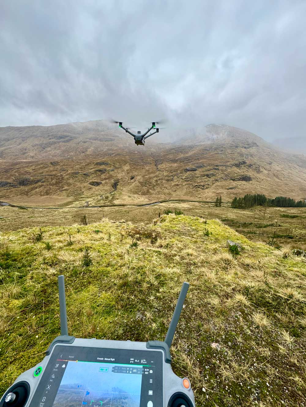
Highland weather rarely waits for convenience, and this survey was no exception. Rain and shifting conditions were part of the operating picture, but the DJI Matrice 4TD proved well suited to the task. Its weather-resistant design allowed flying to continue in conditions that would have grounded less capable aircraft, which meant the survey could stay on schedule rather than losing momentum to every passing shower.
That resilience is a serious operational advantage in Scotland, where waiting for perfect conditions is often unrealistic. A platform that can continue working through variable weather is not just a technical benefit. It directly improves coverage, consistency, and the likelihood of completing the survey within the available window.
Airspace coordination was another important part of the operation. The estate sits within a tactical low flying zone, so flights were coordinated with the RAF to deconflict activity and ensure the work could be carried out safely and responsibly. That level of coordination is essential for professional operations in rural areas where low-level military traffic may be present.
Outcome
The final result was a clear, structured deer count across a very large and challenging estate, completed with greater efficiency and less exposure to ground risk than would have been possible using traditional methods alone. More than 740 deer were identified, classified, and logged, with the survey also providing additional wildlife observations and location context across the wider estate.
Just as importantly, the workflow proved the value of combining thermal search, optical verification, mobile estate support, live connectivity, and field-based power resilience into one coherent system. This was not simply a drone flight over open ground. It was a well-planned survey operation designed to produce reliable outputs in one of the most demanding environments in the UK.
- Surveyed approximately 15,000 acres across Glen Dessary, Glen Pean and Glen Ahurran
- Identified more than 740 deer with visual classification of sex and younger animals
- Used thermal detection followed by 120x zoom verification from roughly 300 to 500 metres
- Logged sightings using intelligent markers to support structured counting and reduce duplication
- Maintained off-grid connectivity using Starlink Mini in areas with no signal
- Kept batteries charging from a mobile Argo-based setup with no unnecessary downtime
- Continued operations in rain using a weather-resistant enterprise drone platform
- Coordinated safely with the RAF within the tactical low flying environment
Reliable deer counts without ground disturbance
Get In Touch
If you need accurate deer population data for estate management, conservation planning or reporting, get in touch with details of the land area and survey objectives. We will advise on timing, approach and expected outputs before providing a clear quote.
Call Us
Monday–Friday, 9am–5pm
Visit Us
By appointment only